Khmer
Khmer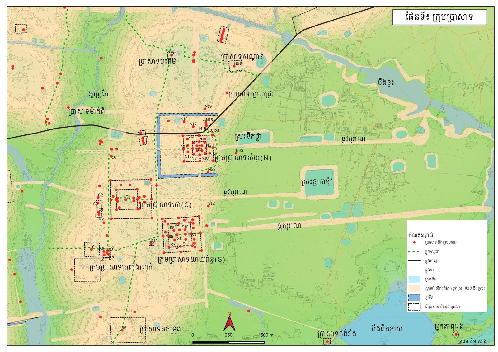
By: MANG Valy, AN Raksmey, SREI Sambunnarong
Supported By: UNESCO Participant Programme 2024-2025
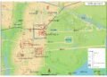
Sambor Prei Kuk, identified as Iśāṇapura, is an archaeological complex situated across a topographically diverse region encompassing both elevated plains and lower-lying floodplains. Geographically, it is located on the west bank of the Stung Sen River. This archaeologically rich zone covers three administrative districts within Kampong Thom Province: Prasat Sambour, Prasat Balangk, and Kampong Svay. International scholarly interest in this significant site began to manifest in the late 1890s, culminating in its successful inscription as a UNESCO World Heritage Site on July 8, 2017.
The inaugural systematic study of the Sambor Prei Kuk temple complex was conducted in 1891 under the direction of Mr. Adhémard Leclère, the former French Résident of Kampong Thom’s colonial administration. The findings of this initial mission were subsequently published in his 1894 report, titled ‘Fouilles de Kompong Soay (Cambodge).’ During this expedition, Leclère cataloged thirteen brick temples within the Sambour and Tao groups, and meticulously documented several sculptures and artifacts located at the site. Following this, in 1896, he ordered the transport of the Hayagriva sculpture—discovered in one of the octagonal sanctuaries in the Sambour Group (Tower N7) —to France for preservation.
Subsequently, the mission led by Mr. Lunet De Lajonquière, dedicated to inventorying Khmer cultural heritage, arrived at the Sambor Prei Kuk area. Due to the seemingly dense forest cover at the time, this renowned French scholar confined his study and inventory only to the Northern group, which comprised a total of 19 temples (Towers A to S) (Lajonquière 1902: 224-236). Following these efforts, an additional twenty ancient temples within the Sambor Prei Kuk zone were newly documented through further research conducted by another French scholar, Mr. Georges Morand, in 1904 (Morand 1907: 17-18).
Between 1911 and 1925, Mr. Henri Parmentier conducted more extensive research, significantly expanding the recorded corpus to 72 brick structures (Parmentier 1927). Concurrently, through the discovery of several inscriptions, Parmentier and Mr. Louis Finot established that the Yeay Pean group of temples was an important construction attributed to King Īśānavarman I (Parmentier 1913: 1-63; Finot 1912: 184-189). This epigraphic work culminated in Finot’s 1931 conclusion that the ancient city at Sambor Prei Kuk was originally named “Iśāṇapura,” based on evidence within the Sambour and Yeay Pean temple inscriptions (Finot 1931: 40-41).
Critical urban planning analysis was undertaken between 1927 and 1938 by Mr. Victor Goloubew, who initiated systematic archaeological excavations, data collection, and aerial photography. This comprehensive approach led him to conclude that the western area, demarcated by a surrounding moat measuring approximately 2 x 2 kilometers, represented the physical urban structure of Iśāṇapura, as established by King Īśānavarman I and corroborated by Chinese historical records (Goloubew 1927: 489-492; 1937: 655; 1938: 442).
In the ensuing decades, scholarly research on this pivotal archaeological site continued consistently, including key contributions across various disciplines: Mr. George Coedès advanced epigraphic studies in the 1950s; Mr. Bernard Philippe Groslier focused on large-scale archaeological excavation in the 1960s; and Ms. Mireille Bénisti specialized in the comparative study of sculpture relative to Indian artistic styles in the 1970s.
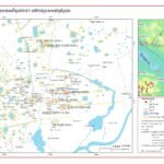
Beginning in the early 2000s, the Sambor Prei Kuk Conservation Project (SCP), led by Waseda University (Japan), initiated a comprehensive program of archaeological research, structural conservation, and human resource development at the site. A key outcome of this collaboration was a significant expansion of the known archaeological inventory. The project’s surveys notably increased the number of recorded stations from the 27 stations (encompassing 72 temples) previously documented by Henri Parmentier in 1927 to 107 stations containing a total of 291 temples. This expanded archaeological zone spans a considerable area of 12.3 kilometers north-south and 12.2 kilometers east-west (Shimoda & Shimamoto 2012:6).
The newly discovered ancient structures are distributed circumferentially around the central temple area. A majority of these findings, however, are concentrated in the western sector, an area designated as the “Ancient Isanapura City Zone.” The structures found in this zone are predominantly constructed of brick, with a smaller proportion utilizing laterite. Despite the substantial increase in the total number of monuments, a crucial finding of the survey concerns the present-day condition of the structures. Out of the 291 total ancient temples, only 47 are classified as being in good, fair, or moderate states of preservation. The overwhelming majority of the remaining structures have suffered significant degradation, having collapsed into brick mounds or becoming indistinguishable earthen tumuli where the original brick and laterite materials are no longer visible on the surface (Shimoda & Shimamoto 2012:7).
For methodological clarity and to facilitate further study and management, the joint Japanese and Khmer research teams of the SCP formally established a bipartite division of the archaeological complex. The site is demarcated into two distinct principal areas: the Moated City Zone and the Temple Zone (alternatively referred to as the Sacred Zone). These two archaeologically significant zones are naturally segregated by a major hydrological feature, a local stream known as the “Ou Krou Kae.”
The Moated City Zone at Ishanapura, a key component of the ancient capital (identified with modern Sambor Prei Kuk), is situated on the western periphery and is defined by a sub-rectangular water enclosure (moat). This sector is characterized by a high concentration of ancient, man-made, rectangular reservoirs and significant archaeological deposits of ceramic artifacts (Shimamoto 2007).
A critical feature of this pre-Angkorian urban planning is the imperfect geometric regularity of the main city moat, where the lengths and angles exhibit slight variance. This contrasts sharply with the hydraulic systems of the later Angkorian era, which are renowned for their strict and uniform orthogonal layouts. Furthermore, the eastern boundary of the enclosure lacks an artificially excavated ditch; instead, the natural Ou Kruo kae stream was intentionally integrated to serve as the eastern moat.
The three man-made segments of the moat (western, northern, and southern) are uniformly dimensioned, measuring approximately 20 meters in width and 1.5 meters in depth. These moats are accompanied by a parallel earthen embankment, measuring 40 meters wide and 1 meter high (Shimoda & Nakagawa 2006). Notably, this rampart is a purely earthen construction, entirely lacking the brick or stone revetment found at other contemporaneous sites, such as the ancient city of Angkor Borei in Takeo province (Stark et al. 1999).
The simplicity of the moat and earthen embankment system at Ishanapura has led researchers, including Shimoda and Shimamoto, to hypothesize that their primary function was not defensive, as is often assumed for ancient city enclosures. Instead, they propose that the infrastructure served a more fundamental role in seasonal water management, specifically for the retention of rainfall during the wet season. Alternatively, the layout may embody religious or cosmological principles derived from Indian influence, which were foundational to the early Khmer polity (Shimoda & Shimamoto 2012:12).
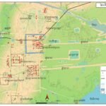
Archaeological investigation near the core of the ancient city of Ishanapura (Sambor Prei Kuk) has revealed a substantial rectangular structure of brick and laterite, measuring 80 x 30 meters (locally termed Prasat Preung). The original function of this imposing structure remains speculative. However, correlation with the historical accounts of the Chinese Sui Dynasty suggests it may correspond to the central royal audience hall described as being situated at the heart of the city (Sui Shu, Zhenla, Volume 82).
Further east of this central feature, at Site M.69, a brick causeway oriented to the east was uncovered. The considerable quantity of roof tiles and fine ceramics recovered from this location leads to the hypothesis that the site represents the location of the royal palace. It is surmised that the palace itself was constructed of perishable materials, likely wood, erected upon the remaining masonry substructure (Shimamoto et al. 2008).
Ishanapura’s urban plan incorporated two principal city gates, one to the west and one to the east, each strategically paired with a religious complex. The East Gate is associated with Prasat Doun Moung, while the West Gate is linked to Prasat Bay Da.
Emanating from the West Gate is an ancient road extending southward, traversing approximately 150 kilometers to the region of Angkor (Nagumo & Kubo 2007). Contemporary evidence of this road, including both straight and curvilinear segments, is still discernible in the southern Angkor area. Scholars Kubo and Nagumo propose that this road network was established as early as the pre-Angkorian period (7th century), citing its trajectory toward Prasat Andaet (San Kor commune), a structure dated to the 7th century, as supporting evidence. This suggests a significant and early connection between Ishanapura and the subsequent center of the Khmer Empire (Nagumo & Kubo 2018: 158).
In 2016, a team of Japanese researchers, operating under the SCP project (Specific Cultural Preservation or similar project name in a formal context), conducted an archaeological investigation at the ancient city of Ishanapura. The research involved extracting and analyzing soil cores from multiple locations across the site’s moats and reservoirs to establish chronological markers for construction and settlement.
Radiocarbon dating (C14 analysis) of the soil samples provided several key chronological insights:
Moat Construction: The results suggest the primary water moats were likely constructed around the 6th century CE.
Later Deposits: Pottery sherds recovered from the stratum immediately overlying the moat fill layers were dated to a subsequent period, ranging from the 9th to the 11th centuries CE (Nogumo & Kubo 2018: 162).
Early Settlement Trace: Cultural debris found along the course of a modern red gravel road (which intersects the ancient city) yielded even earlier dates, with some remnants assigned to the 5th century CE and others to the 6th or 7th centuries.
A significant finding was recorded at loci M78/M79, where the archaeological evidence pointed to continuous land use spanning from the 5th century through the 14th century CE (ibid.).
This extensive chronological range is highly significant, as it demonstrates that Ishanapura persisted as a vital regional center with continuous human habitation for centuries. This sustained occupation occurred despite the major political shift in the region, specifically the relocation of the royal capital to the Angkor area following the rise of the Angkorian Empire. The data thus challenges interpretations that suggest a complete abandonment of the former capital upon the transfer of political power.
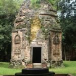
The Temple Zone comprises a dense concentration of religious edifices constructed predominantly from brick and laterite. The area’s principal temples are organized into three major functional and/or spatial groups: the Prasat Sambor Group, the Prasat Tao Group, and the Prasat Yeay Poan Group. This core is supplemented by several minor temple assemblages, notably the Prasat Trapeang Ropeak Group and the Prasat Kuok Troung Group. Furthermore, the Temple Zone integrates an extensive hydraulic infrastructure, including ancient moats, reservoirs (ponds/tanks), excavated canals, and causeway bridges.
A significant architectural distinction among the three major complexes is that only the Prasat Sambor Group features a concentric system of three enclosure walls. This triple-enclosure configuration aligns with the typical monumental architectural layouts observed at later large-scale Angkorian temple sites. The outermost boundary is defined by an ancient moat/water enclosure. The two inner ramparts are constructed of laterite and form a regular square perimeter, each measuring 389 meters in length.
Archaeological observations at the Sambor Prei Kuk complex—the former capital of Ishanapura—highlight the structured monumental approach to the ancient city. Specifically, in front of both the Sambor temple group (the northern complex) and the Yeay Poan temple group (the southern complex), a significant earthen embankment was raised to create an elevated causeway. This causeway extended eastward over a distance of more than two kilometers, establishing a direct connection between the temple complexes and the Sen River.
In contrast, archaeological evidence for a similar causeway structure leading to the Prasat Tao group (the central complex) remains ambiguous and less clearly preserved. This is primarily attributed to the current land use of the area, which has been converted to agricultural rice fields, likely obscuring the original structural contours.
The functional and symbolic role of the two prominent causeways has been the subject of scholarly analysis. Japanese researchers Shimoda and Shimamoto posit that these two structures constituted the principal eastern ingress points to the metropolitan area of Ishanapura. They further suggest that the construction of these imposing features was instrumental in projecting the capital’s authority and enhancing its visual appeal to arriving dignitaries. This interpretation is reinforced by historical evidence indicating that foreign merchants and diplomatic envoys traveling to the city typically navigated the Sen River and subsequently accessed Ishanapura through these monumental causeways (Shimoda & Shimamoto 2012:11).
The ancient Temple Zone of Sambor Prei Kuk features a significant hydraulic infrastructure that extends beyond its prominent religious edifices and causeways. This system includes a crucial artificial canal, precisely measured at 4.3 kilometers, designed to channel water from the northeast to the southeast. This waterway, characterized by its substantial dimensions—approximately 25 meters in width and 5 meters in depth—was engineered to capture water from the Ou Krou Kae stream at the confluence point of Anlong Chambak and direct it toward the Stung Sen River.
Collectively, the geographical placement of the Sambor Prei Kuk Temple Zone, situated on the western bank of the Stung Sen River, represents an optimal environment for the foundation of a major urban center. This suitability stems from two primary factors: the capacity for effective mitigation of monsoon flooding and the capability for comprehensive incorporation of water resources for internal civic use.
Moreover, the connectivity established between the capital, Ishanapura, and the Stung Sen via an extensive network of major and minor canals likely facilitated efficient transportation of goods and movement of the population, particularly during periods of elevated water levels. It is hypothesized that these various waterways converged at a primary riverine access point. Japanese archaeological research suggests that the ancient port was situated at Kampong Chheu Teal village, a theory supported by the discovery of laterite architectural remnants at the site.
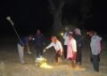
These significant geographical advantages are posited as the fundamental drivers for the continuous human occupation of Ishanapura from antiquity to the contemporary era. This enduring settlement pattern has, consequently, allowed for the rich and diverse preservation of traditional religious beliefs and ceremonial practices within the region.
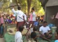
This research project focuses on the animistic ritual practices of communities residing within a 25-kilometer radius of the Sambor Prei Kuk World Heritage Site. The study’s scope encompasses 15 target villages located across three administrative districts: Prasat Sambo, Kampong Svay, and Prasat Balangk. Ethnically, the sample includes four Kuoy villages (Veal Veaeng, Koun K’aek, Andas, and Ta Laek Thmey) and eleven Khmer villages, all of which are noted for preserving rich, archaic traditional customs.
The rapid pace of socio-economic development is fundamentally transforming the traditional lifestyles of the local inhabitants. Historically, communities near Sambor Prei Kuk relied on traditional agriculture. Khmer residents primarily engaged in wet-season rice cultivation and fisheries, while the Kuoy were distinguished by their practice of rotational shifting cultivation (srov chamkar) and the collection of non-timber forest products (NTFPs).
The widespread adoption of modern irrigation infrastructure and agricultural mechanization has compelled a significant shift in farming practices. There is a growing preference for dry-season rice cultivation (irrigated rice) over the traditional wet-season crop. This preference is driven by its perceived advantages: easier management, the potential for multiple annual harvests, a reduced crop cycle, faster yield collection, and overall higher productivity. This transition reflects a national trend across Cambodia. The reliance on direct seeding for dry-season rice is incrementally leading to the disuse of traditional rice transplanting and, consequently, the decline of communal labor systems, or reciprocal assistance (prâvâh dai), which is now mostly limited to immediate family units. Notably, the Kuoy minority is the most consistent group maintaining this communal labor tradition. Furthermore, the Kuoy’s distinctive method of rotational shifting cultivation, which involves dibbling seeds into holes made with wooden poles, is now largely marginalized. This is primarily attributed to the current scarcity of forest land available for the requisite slash-and-burn land preparation, which traditionally occurred between the months of Meak and Chet (January to April).
Beyond rice, several cash crops—notably cashew, cassava, corn, beans, and sesame—provide supplemental household income. Adults and older children, outside of rice-tending or schooling, dedicate their time to cultivating these crops. Cashew nuts yield an average of 4,000–6,000 Riel/kg, and cassava sells for 150–300 Riel/kg. Concurrently, traditional income-generating activities, such as palm tree tapping, palm sugar production, and the sale of fermented palm juice (tuek tnaot chur), have significantly diminished. Among the 15 study villages, only Cheay Sampov retains active palm sugar production.
Despite the shift toward industrial cropping, the Kuoy community sustains its practice of NTFP collection. They frequently gather small vines (e.g., rôpeak, rattan/ pdau, chhnour) for weaving domestic goods and market sale. The indigenous tradition of basket weaving (trâk) remains particularly vital to the Kuoy identity. However, the traditional process of distilling tree resin (from chhoeutéal and chôr chong) with chrômas and sâmbâk smaoch tuok bark to manufacture torches (chânlôh) is now rarely practiced. An important seasonal activity for both Kuoy and Khmer is the gathering of wild kuy fruit during Phalkuna and Chetra (March/April) for both subsistence and market sale due to its high value.
The northern village of Kampong Chheu Teal exhibits the highest concentration of residents of Chinese descent, predominantly tracing their ancestry to the Hokkien lineage. A significant finding is the near-total loss of the Hokkien dialect within this community. This contrasts sharply with the Teochew Chinese groups in other parts of Cambodia, which have successfully maintained generational linguistic proficiency. According to William E.
Willmott’s analysis, the Hokkien group has a historical propensity for rapid assimilation with the Khmer population, leading to an almost indistinguishable ethnic identity—a factor posited as the primary driver for the dialect’s disappearance in Kampong Chheu Teal. These Chinese descendants, who predominantly settle along the Stung Sen River, are highly skilled entrepreneurs, though some are also employed as educators, civil servants, company staff, and farmers. Despite their distinct heritage, they are well-integrated, maintaining strong social ties with neighbors and consistently participating in the community’s animistic rituals.
A critical demographic trend is the escalating phenomenon of labor migration (“out-migration”). This movement is principally motivated by the inadequate availability of agricultural land to support household economies. The primary destinations for these migrants seeking manual labor are Thailand and, to a lesser extent, South Korea. A significant portion also migrates internally to Phnom Penh to work in the construction or industrial factory sectors. In some cases, both spouses are forced to migrate, leaving their children in the care of elderly relatives. This out-migration poses a profound challenge to the preservation of community animistic rituals, as the able-bodied adults—who are the primary carriers and future inheritors of this intangible cultural heritage—are absent and unable to participate in the ceremonies.
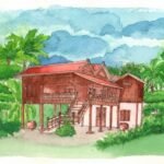
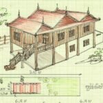
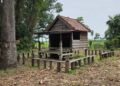
Despite the broader societal modernization, the physical form of residential structures has remained largely consistent across Khmer, Kuoy, and Chinese-descended households over the past several decades. The prevailing architectural style is the traditional elevated wooden house on pillars. The Kântaing house type (one-, two-, or three-section variants) is the most common, while the Bâït house type has become exceedingly rare, and other forms like Rong Daol, Rong Dueung, and Kaeng are almost nonexistent.
However, villages within the Sambor Prei Kuk protected zone are now subject to strict architectural guidelines. The National Authority for Sambor Prei Kuk mandates that new construction adhere to pre-approved traditional Khmer wooden house models (including Rong Daol, Bâït, Kântaing, and Kaeng), offering over 20 designs, some of which feature a mixed construction of wood above a single stone room below. In Protection Zones 2 and 3, fully stone-built homes may be permitted, provided they maintain the authentic structural and aesthetic form of traditional Khmer architecture (e.g., by being painted to simulate wood grain).